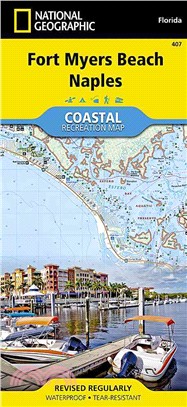
National Geographic Fort Myers Beach, Naples ─ Florida
商品資訊
系列名:National Geographic Trails Illustrated Map
ISBN13:9781566956765
出版社:Natl Geographic Maps
作者:National Geographic Maps - Trails Illustrated (COR)
出版日:2013/01/01
裝訂/頁數:平裝/2頁
規格:23.5cm*10.8cm*0.3cm (高/寬/厚)
商品簡介
相關商品
商品簡介
‧ Waterproof ‧ Tear-Resistant ‧ Topographic Map
National Geographic's Fort Myers Beach - Naples Coastal Recreation map is the ideal companion for adventures along shore and on the water.
National Geographic's new family of Coastal Recreation maps are two-sided, waterproof maps designed specifically for recreation along America's most beautiful shorelines. These hybrid maps strike the perfect balance between professional boating charts and detailed topographic maps for land. There is no other map in the market today that provides as much versatility for coastal recreation as National Geographic's Coastal Recreation series. For paddlers, sail, and power boaters these maps are ideal for planning, cover waters up to three nautical miles off-shore, conveniently sized for use on-board a craft ofany size, packed with essentially boating information, and a valuable safety companion. Beach-goers, wildlife enthusiasts, and those that enjoy exploring coastal towns will find these maps an invaluable resource for local beaches, parks, wildlife viewing areas, lighthouses, and unique places of interest.
The Fort Myers Beach - Naples Coastal Recreation map covers the SW Florida coast from Estero Bay and the eastern tip of Sanibel Island south to Rookery Bay at a detailed scale of 1:40,000 (1" = 0.63 Mile). The front side of the map details Estero Bay, Fort Myers, Bonita Beach, Hickory Bays and the north end of Delnor Wiggins Pass State Park. The reverse, with overlapping coverage, details the coastline from Delnor-Wiggins Pass State Park, Naples, Clam Pass, Gordon, Pass and Rookery Bay.
The Fort Myers Beach - Naples map is designed and printed in the United States on durable synthetic paper, making it waterproof, tear-resistant and capable of going anywhere you do. The map is two-sided, and is folded to a convenient size of 4.25" x 9.25" ; unfolded size is 26" x 38". These maps fit easily in lifejacket, center console, or glove box.
Key Features:Waterproof and tear-resistant Updated regularly Designed and printed in the U.S.A Detailed shoreline Bathymetry with marine aids to navigation Marinas, boat ramps, and access points. Beaches, shoreline parks, and wildlife refuges Detailed topography with clearly marked trails for hiking, paddling, biking, powersports, horseback riding, and more Color-coded boundaries for parks, recreation areas, wilderness areas, sanctuaries and wildlife refuges Hundreds of places-of-interest, including: beaches, lighthouses, campgrounds, information centers, trailheads, viewpoints, boat launches, canoe carry downs, fishing access points, scuba diving hot spots, and specialty content unique to each area UTM and Latitude/Longitude grid, as well as selected waypoints and a scale bar for easy and accurate navigation.
National Geographic Coastal Recreation maps also contain helpful information on local regulations, safety, travel tips, local contact information, and interpretive information.
Scale: 1:40:000 (1"=0.63 Miles)
Copyright: 2013
Net proceeds from the sale of this map go to support the nonprofit mission of the National Geographic Society.
National Geographic's Fort Myers Beach - Naples Coastal Recreation map is the ideal companion for adventures along shore and on the water.
National Geographic's new family of Coastal Recreation maps are two-sided, waterproof maps designed specifically for recreation along America's most beautiful shorelines. These hybrid maps strike the perfect balance between professional boating charts and detailed topographic maps for land. There is no other map in the market today that provides as much versatility for coastal recreation as National Geographic's Coastal Recreation series. For paddlers, sail, and power boaters these maps are ideal for planning, cover waters up to three nautical miles off-shore, conveniently sized for use on-board a craft ofany size, packed with essentially boating information, and a valuable safety companion. Beach-goers, wildlife enthusiasts, and those that enjoy exploring coastal towns will find these maps an invaluable resource for local beaches, parks, wildlife viewing areas, lighthouses, and unique places of interest.
The Fort Myers Beach - Naples Coastal Recreation map covers the SW Florida coast from Estero Bay and the eastern tip of Sanibel Island south to Rookery Bay at a detailed scale of 1:40,000 (1" = 0.63 Mile). The front side of the map details Estero Bay, Fort Myers, Bonita Beach, Hickory Bays and the north end of Delnor Wiggins Pass State Park. The reverse, with overlapping coverage, details the coastline from Delnor-Wiggins Pass State Park, Naples, Clam Pass, Gordon, Pass and Rookery Bay.
The Fort Myers Beach - Naples map is designed and printed in the United States on durable synthetic paper, making it waterproof, tear-resistant and capable of going anywhere you do. The map is two-sided, and is folded to a convenient size of 4.25" x 9.25" ; unfolded size is 26" x 38". These maps fit easily in lifejacket, center console, or glove box.
Key Features:
National Geographic Coastal Recreation maps also contain helpful information on local regulations, safety, travel tips, local contact information, and interpretive information.
Scale: 1:40:000 (1"=0.63 Miles)
Copyright: 2013
Net proceeds from the sale of this map go to support the nonprofit mission of the National Geographic Society.
- Map Scale = 1:40,000
- Sheet Size = 37.75" x 25.5"
- Folded Size = 4.25" x 9.25"
主題書展
更多
主題書展
更多書展今日66折
您曾經瀏覽過的商品
購物須知
外文書商品之書封,為出版社提供之樣本。實際出貨商品,以出版社所提供之現有版本為主。部份書籍,因出版社供應狀況特殊,匯率將依實際狀況做調整。
無庫存之商品,在您完成訂單程序之後,將以空運的方式為你下單調貨。為了縮短等待的時間,建議您將外文書與其他商品分開下單,以獲得最快的取貨速度,平均調貨時間為1~2個月。
為了保護您的權益,「三民網路書店」提供會員七日商品鑑賞期(收到商品為起始日)。
若要辦理退貨,請在商品鑑賞期內寄回,且商品必須是全新狀態與完整包裝(商品、附件、發票、隨貨贈品等)否則恕不接受退貨。


