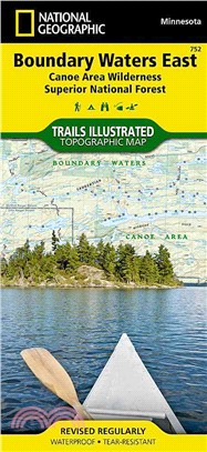
National Geographic Boundary Waters Canoe Area Wilderness East ― Trails Illustrated Map, Superior National Forest Minnesota, USA
商品資訊
系列名:National Geographic Trails Illustrated Map
ISBN13:9781566955027
出版社:Natl Geographic Society Maps
作者:National Geographic Society (U. S.)
出版日:2010/05/15
裝訂:平裝
規格:10.8cm*23.5cm*0.6cm (高/寬/厚)
商品簡介
相關商品
商品簡介
• Waterproof • Tear-Resistant • Topographic Map
The water-rich Superior National Forest includes more than 2,000 lakes and rivers that offer a chance to canoe, boat, fish and camp where early Native Americans, voyageurs, missionaries, loggers and explorers once traveled. About a third of the Forest lies within the Boundary Waters Canoe Area Wilderness (BWCAW). Visitors to the BWCAW will find a sense of solitude and primitive recreation; permits are required and special regulations apply.
The Boundary Waters was recognized for recreational opportunities in 1926, named the Superior Roadless Area in 1938, the BWCA in 1958, and federally designated under The Wilderness Act in 1964. It wasn't until October 21, 1978, The Boundary Waters Canoe Area Wilderness Act was established to provide specific guidance for managing the million plus acres of the Superior National Forest.
The BWCAW has changed little since the glaciers melted. With over 1,500 miles of canoe routes, nearly 2,200 designated campsites, and more than 1,000 lakes and streams waiting, the BWCAW draws over 250,000 visitors each year. As part of the Superior National Forest, the BWCAW is managed by the US Forest Service.
Coverage Highlights
Areas and places featured in this map include:
• Hiking trails, portages, cross-country, snowmobile and snowshoe trails, trail access locations, campgrounds and tent sites, birding, fishing, kayak, canoeing and power boating opportunities
• Ash River, Crane Lake, Kabetogama and Rainy Lake Visitor Centers
• Park Attractions: Gull Island Rookery, Grassy Bay Cliffs, Anderson Bay, Kettle Falls, Hoist Bay, Gold Portage
- Map Scale = 1:70,000
- Sheet Size = 37.75" x 25.5"
- Folded Size = 4.25" x 9.25"
主題書展
更多
主題書展
更多書展今日66折
您曾經瀏覽過的商品
購物須知
外文書商品之書封,為出版社提供之樣本。實際出貨商品,以出版社所提供之現有版本為主。部份書籍,因出版社供應狀況特殊,匯率將依實際狀況做調整。
無庫存之商品,在您完成訂單程序之後,將以空運的方式為你下單調貨。為了縮短等待的時間,建議您將外文書與其他商品分開下單,以獲得最快的取貨速度,平均調貨時間為1~2個月。
為了保護您的權益,「三民網路書店」提供會員七日商品鑑賞期(收到商品為起始日)。
若要辦理退貨,請在商品鑑賞期內寄回,且商品必須是全新狀態與完整包裝(商品、附件、發票、隨貨贈品等)否則恕不接受退貨。


