

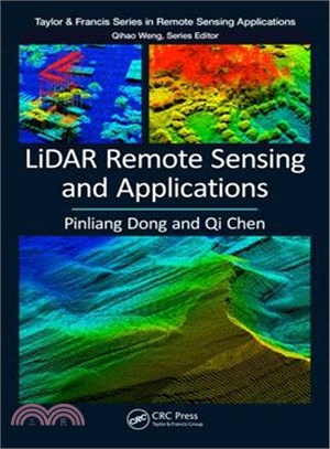
Lidar Remote Sensing and Applications
商品資訊
系列名:Remote Sensing Applications
ISBN13:9781138747241
出版社:CRC Pr I Llc
作者:Pinliang Dong; Qi Chen
出版日:2017/12/29
裝訂/頁數:平裝/222頁
規格:23.5cm*15.2cm*1.3cm (高/寬/厚)
商品簡介
LiDAR (Light Detection and Ranging) is a remote sensing technology that measures distance by illuminating a target with a laser and analyzing the reflected light. This book introduces the fundamentals of LiDAR remote sensing, LiDAR data processing and analysis methods and applications of LiDAR in forestry and vegetation mapping, urban environments, and geosciences. It includes 11 hands-on projects with step-by-step instructions and many up-to-date studies, and can be used as a textbook or reference in fields related to those listed above
作者簡介
Dr. Pinliang Dong is a Professor in the Department of Geography and the Environment, University of North Texas (UNT), Denton, TX, USA. He received his B.Sc. in geology from Peking University, China in 1987, M.Sc. in cartography and remote sensing from the Institute of Remote Sensing Applications, Chinese Academy of Sciences in 1990, and Ph.D. in geology from the University of New Brunswick, Canada in 2003. Before joining UNT in 2004, he worked as a Senior GIS Analyst/Programmer at Titan Corporation in California (USA) and Okinawa (Japan), and a Staff Associate/GIS Specialist at the Center for International Earth Science Information Network (CIESIN), Columbia University. His research interests include remote sensing, geographic information systems (GIS), digital image analysis, and LiDAR applications in forestry, urban studies, and geosciences. He has taught Intermediate GIS, Advanced GIS, Advanced GIS Programming, Remote Sensing, Special Topics in GIS: LiDAR Applications, and China Field School; mentored over 30 Master’s and doctoral students and two post-doctoral fellows; and hosted over 15 international visiting scholars. He is a member of the American Association of Geographers (AAG), American Geophysical Union (AGU), and International Society for Digital Earth (ISDE).
Dr. Qi Chen is a Professor in the Department of Geography at the University of Hawaii at Manoa, Honolulu, Hawaii, USA. He received his B.Sc. and M.Sc. in Geography in 1998 and 2001, respectively, from Nanjing University, China, and Ph.D. in Environmental Sciences, Policy, and Management from the University of California, Berkeley, USA in 2007. He joined the University of Hawaii at Manoa as a tenure-track Assistant Professor in 2007, was tenured and promoted to Associate Professor in 2012, and was promoted to Professor in 2017. His early interest and research in LiDAR remote sensing during his Ph.D. study were to develop effective methods for LiDAR data processing and information extraction, including airborne LiDAR point cloud filtering, digital terrain model generation, and individual tree mapping. His research in recent years has expanded to satellite LiDAR, terrestrial LiDAR, and the use of LiDAR for extracting various vegetation attributes for applications such as wildfire mapping and hazard analysis, biodiversity and habitat analysis, and biomass mapping and estimation. His overall interest in LiDAR remote sensing is to improve the methods of information extraction from LiDAR and to promote the use of LiDAR for assisting environmental management and decision making. He is an advisor to many Master’s and doctoral students, postdocs, and has hosted many international students and professors for studying LiDAR in his research lab. He has also given multiple tutorial workshops on LiDAR remote sensing in international conferences organized by professional societies.


今日66折


您曾經瀏覽過的商品

購物須知
外文書商品之書封,為出版社提供之樣本。實際出貨商品,以出版社所提供之現有版本為主。部份書籍,因出版社供應狀況特殊,匯率將依實際狀況做調整。
無庫存之商品,在您完成訂單程序之後,將以空運的方式為你下單調貨。為了縮短等待的時間,建議您將外文書與其他商品分開下單,以獲得最快的取貨速度,平均調貨時間為1~2個月。
為了保護您的權益,「三民網路書店」提供會員七日商品鑑賞期(收到商品為起始日)。
若要辦理退貨,請在商品鑑賞期內寄回,且商品必須是全新狀態與完整包裝(商品、附件、發票、隨貨贈品等)否則恕不接受退貨。