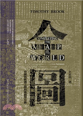
全圖:中國與歐洲之間的地圖學互動
商品資訊
ISBN13:9789865432638
替代書名:Completing the map of the world: Cartographic interaction between China and Europe
出版社:中研院-近代史研究所
作者:卜正民(Timothy Brook)
出版日:2020/12/01
裝訂/頁數:精裝/219頁
規格:21cm*14.8cm*2.8cm (高/寬/厚)
重量:667克
商品簡介
1644年,南京一位名叫曹君義的出版商,印製了一幅獨特的世界地圖,他稱之為「天下全圖」。其雖沿襲了某些可上溯宋元時期的中國慣例,卻也借鑒了一幅由奧特柳斯(Ortelius)設計、耶穌會傳教士利瑪竇在南京印製的歐洲版世界地圖。現今在兩個國家圖書館中仍保存了曹君義版地圖:其一在北京,另一在倫敦。本書的兩個章節,原是發表在中央研究院郭廷以學術講座的講稿,每章即是以這兩本曹君義地圖中的一本作為出發點,去重建一段世界地圖的歷史,以此回顧早期的中國和歐洲在繪製世界地圖上的嘗試,並展望中國的世界地圖(如曹君義的版本)對歐洲地圖學的影響。這段歷史表明了:歐洲人仰賴中國人對亞洲的知識,並不亞於中國人倚賴歐洲人對世界的認識。今日我們所知道的世界地圖,正是在這種相互作用下,於焉誕生。
Completing the Map of the World: Cartographic Interaction between China and Europe
In 1644, a Nanjing publisher named Cao Junyi printed a unique world map that he called “a complete map of all under Heaven.” He followed certain Chinese conventions going back to the Song and Yuan dynasties, but he also drew on a European map of the world designed by Ortelius and printed in Nanjing by the Jesuit missionary Matteo Ricci. Copies of this map survive today in two national libraries, one in Beijing and the other in London. The two chapters of this book, originally delivered as the Kuo Ting-yee Memorial Lectures at Academic Sinica, each take one of these copies of Cao’s map as points of departure to reconstruct a history of world maps that looks back to earlier Chinese and European attempts to map the world and forward to the effects that Chinese world maps like Cao’s had on European cartography. This history reveals that Europeans depended on Chinese knowledge of Asia just as much as Chinese depended on European knowledge of world. Out of this interaction emerged the map of the world as we know it today.
主題書展
更多書展今日66折
您曾經瀏覽過的商品
購物須知
為了保護您的權益,「三民網路書店」提供會員七日商品鑑賞期(收到商品為起始日)。
若要辦理退貨,請在商品鑑賞期內寄回,且商品必須是全新狀態與完整包裝(商品、附件、發票、隨貨贈品等)否則恕不接受退貨。


